Hastings NE & Kool-Aid
Hastings, Nebraska
Hastings, Nebraska | |
|---|---|
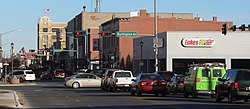
 Downtown Hastings: 2nd Street, looking eastward (2012) | |
 | |
| Coordinates: 40°35′21″N 98°23′30″WCoordinates: 40°35′21″N 98°23′30″W | |
| Country | United States |
| State | Nebraska |
| County | Adams |
| Area | |
| • Total | 14.77 sq mi (38.25 km2) |
| • Land | 14.59 sq mi (37.80 km2) |
| • Water | 0.18 sq mi (0.46 km2) |
| Elevation | 1,926 ft (587 m) |
| Population | |
| • Total | 24,907 |
| • Estimate (2019)[3] | 24,692 |
| • Density | 1,692.04/sq mi (653.29/km2) |
| Time zone | UTC−6 (CST) |
| • Summer (DST) | UTC−5 (CDT) |
| ZIP codes | 68901-68902 |
| Area code | 402 |
| FIPS code | 31-21415 |
| GNIS ID | 0829848[4] |
| U.S. Routes | |
| Website | cityofhastings.org |
Hastings is a city and county seat of Adams County, Nebraska, United States.[5] The population was 24,907 at the 2010 census. It is known as the town where Kool-Aid was invented by Edwin Perkins in 1927, and celebrates that event with the Kool-Aid Days festival every August.[6] Hastings is also known for Fisher Fountain, and during World War II operated the largest Naval Ammunition Depot in the United States. It was chosen because of its centralized location from North to South and East and West in the country. This made it quicker to send ammunition by train to wherever needed.

Comments
Post a Comment